Majapahit_Core_and_Provinces.svg

Size of this PNG preview of this SVG file:
512 × 228 pixels
.
Other resolutions:
320 × 143 pixels
|
640 × 285 pixels
|
1,024 × 456 pixels
|
1,280 × 570 pixels
|
2,560 × 1,140 pixels
.
Summary
| Description |
English:
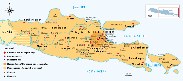
The map depicting Majapahit main area, which consist of Nagara Agung (core realm/capital city) and Mancanagara (provinces) in Central Java, East Java, Madura and Bali. Majapahit is a 13th to 15th century Javanese kingdom, centered in Trowulan, East Java, and spread its influence to much of Indonesian archipelago.
Bahasa Indonesia:
Peta menggambarkan kawasan utama Majapahit yang terdiri atas Nagara Agung (pusat kerajaan di Trowulan), dan wilayah-wilayah Mancanagara (provinsi) yang terdapat di Jawa Tengah, Jawa Timur, pulau Madura dan Bali. Kerajaan Majapahit adalah kerajaan Jawa yang berpusat di Trowulan, Jawa Timur, dan kemudian melebarkan pengaruhnya ke sebagian besar kepulauan Nusantara (kini Indonesia).
|
| Date | |
| Source | Own work |
| Author | Gunawan Kartapranata |
Licensing
I, the copyright holder of this work, hereby publish it under the following license:
This file is licensed under the
Creative Commons
Attribution-Share Alike 4.0 International
license.
-
You are free:
- to share – to copy, distribute and transmit the work
- to remix – to adapt the work
-
Under the following conditions:
- attribution – You must give appropriate credit, provide a link to the license, and indicate if changes were made. You may do so in any reasonable manner, but not in any way that suggests the licensor endorses you or your use.
- share alike – If you remix, transform, or build upon the material, you must distribute your contributions under the same or compatible license as the original.