Lower_White_River_Wilderness_(8614110893).jpg

Size of this preview:
800 × 600 pixels
.
Other resolutions:
320 × 240 pixels
|
640 × 480 pixels
|
1,024 × 768 pixels
|
1,280 × 960 pixels
|
2,048 × 1,536 pixels
.
Summary
| Description |
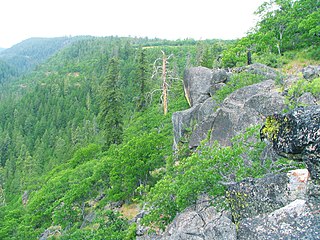
The United States Congress designated the Lower White River Wilderness (map) in 2009 and it now has a total of 2,806 acres. All of this wilderness is located in Oregon and is managed by the Bureau of Land Management and the Forest Service. The White River rises in the high Cascades in western Wasco County, in the Mount Hood National Forest on the southeast flank of Mount Hood. The headwaters are just below White River Glacier in White River Canyon. Additions to the Mount Hood Wilderness protect upper portions of the river, while the Lower White River Wilderness, southeast of the Mount hood Wilderness and east of highway 26, protects a segment of lower river stretch. |
| Date | |
| Source | Lower White River Wilderness |
| Author | Bureau of Land Management |
| Camera location |
|
View this and other nearby images on: OpenStreetMap |
|
|---|
.jpg¶ms=045.147179_N_-121.425704_E_globe:Earth_type:camera_source:Flickr_&language=en)
Licensing
This file is licensed under the
Creative Commons
Attribution 2.0 Generic
license.
-
You are free:
- to share – to copy, distribute and transmit the work
- to remix – to adapt the work
-
Under the following conditions:
- attribution – You must give appropriate credit, provide a link to the license, and indicate if changes were made. You may do so in any reasonable manner, but not in any way that suggests the licensor endorses you or your use.
|
|
This image, originally posted to Flickr , was reviewed on 5 September 2013 by the administrator or reviewer File Upload Bot (Magnus Manske) , who confirmed that it was available on Flickr under the stated license on that date. |
|
|
This image is a work of a
Bureau of Land Management
* employee, taken or made as part of that person's official duties. As a
work
of the
U.S. federal government
, the image is in the
public domain
in the United States.
*or predecessor organization |
|