Leonhard_Euler_World_Map_AD1760.jpg

Size of this preview:
696 × 599 pixels
.
Other resolutions:
279 × 240 pixels
|
557 × 480 pixels
|
892 × 768 pixels
|
1,189 × 1,024 pixels
|
2,378 × 2,048 pixels
|
2,615 × 2,252 pixels
.
Summary
| Description |
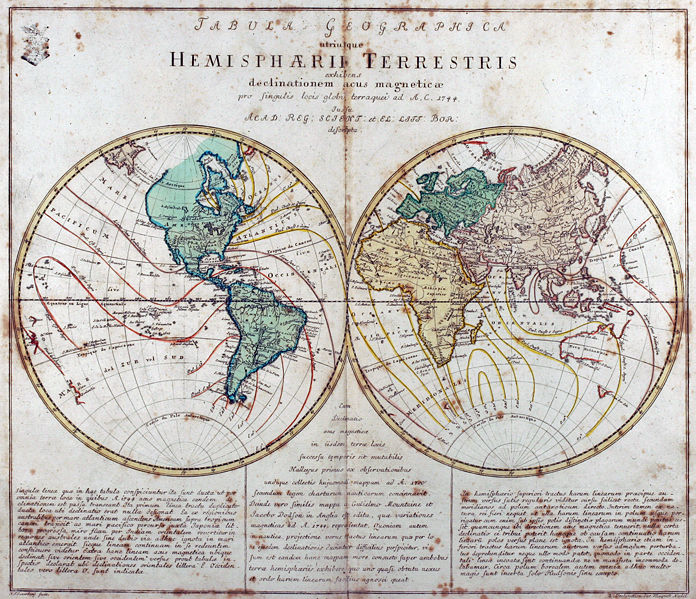
Tabula Geographica utriusque Hemisphaerii Terrestris exhibens declinationem acus magneticae pro singulis locis globi terraquei ad A. C. 1744. Iussu Acad: Reg: Scient: et El: Litt: Bor: descripta.
Deutsch:
Kupferstich-Weltkarte von Leonhard Euler aus seinem Schulatlas
Geographischer Atlas bestehend in 44 Land-Charten
erstmals 1753 in Berlin erschienen
English:
Engraved world map (including magnetic declination lines) by Leonhard Euler from his school atlas “Geographischer Atlas bestehend in 44 Land-Charten” first published 1753 in Berlin
|
||||||||||||||||||||||||||
| Date | |||||||||||||||||||||||||||
| Source | Antique-World: Antique World Map by Leonhard Euler | ||||||||||||||||||||||||||
| Author |
|
||||||||||||||||||||||||||
|
Permission
( Reusing this file ) |
Own work | ||||||||||||||||||||||||||

Licensing
|
|
This work is in the public domain in its country of origin and other countries and areas where the copyright term is the author's life plus 100 years or fewer . This work is in the public domain in the United States because it was published (or registered with the U.S. Copyright Office ) before January 1, 1929. |
| This file has been identified as being free of known restrictions under copyright law, including all related and neighboring rights. | |