Lebak_Tsunami.jpg

Size of this preview:
629 × 599 pixels
.
Other resolutions:
252 × 240 pixels
|
504 × 480 pixels
|
806 × 768 pixels
|
1,075 × 1,024 pixels
|
2,150 × 2,048 pixels
|
3,823 × 3,642 pixels
.
Summary
| Description |
English:
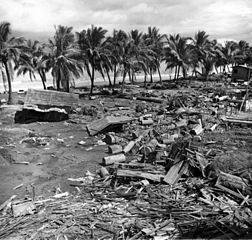
Tsunami disaster at barangay Tibpuan - Tsunami damage at Lebak, caused by the earthquake of magnitude (Ms)= 7.9, in Moro Gulf. Island of Mindanao, Philippines. August 16, 1976. [Earthquake occurred August 16, 1976, centered at 6.3 degrees north and 124.0 degrees east. The earthquake killed about 8,000 people] Published on back cover of U.S. Geological Survey. Earthquake Information Bulletin. v. 14. no. 4. July-August 1982.
|
| Date | |
| Source |
http://libraryphoto.cr.usgs.gov/cgi-bin/show_picture.cgi?ID=ID.%20Wallace,%20R.E.%20%20313&SIZE=medium
U.S. Geological Survey Photographic Library |
| Author | Wallace, R.E. 313 |
Licensing
|
|
This image is in the
public domain
in the United States because it only contains materials that originally came from the
United States Geological Survey
, an agency of the
United States Department of the Interior
. For more information, see
the official USGS copyright policy
.
|
|