LIDAR_field_yield.jpg
No higher resolution available.
Summary
| Description |
English:
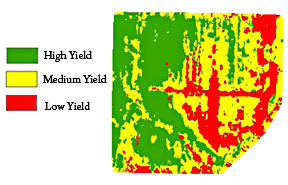
Agricultural Research Service researchers have developed a way to make more precise agricultural maps of fields from data generated by LIDAR (light detection and ranging) sensors to help farmers target more of their resources to the highest-yielding parts of their fields.
|
| Date | |
| Source | https://www.ars.usda.gov/is/pr/2010/100609.htm |
| Author | USDA/ARS/James M. McKinion |
Licensing
|
|
This image is in the
public domain
because it contains materials that originally came from the
Agricultural Research Service
, the research agency of the
United States Department of Agriculture
.
|
|
Original upload log
Transferred from en.wikipedia to Commons using FtCG .
The original description page was
here
. All following user names refer to en.wikipedia.
| Date/Time | Dimensions | User | Comment |
|---|---|---|---|
| 10:39, 7 September 2010 | 288 × 185 (112,175 bytes) | w:en:Huntster ( talk | contribs ) | (Crop and rm compression artifacts.) |
| 21:04, 17 August 2010 | 288 × 252 (77,555 bytes) | w:en:Wikiproject1400 ( talk | contribs ) | (Agricultural Research Service scientists have developed a way to incorporate LIDAR with yield rates on agricultural fields. This technology will help farmers direct their resources towars the high-yield sections of their land. (United States Department o) |