KL_Road_Map.svg

Size of this PNG preview of this SVG file:
251 × 599 pixels
.
Other resolutions:
100 × 240 pixels
|
201 × 480 pixels
|
322 × 768 pixels
|
429 × 1,024 pixels
|
858 × 2,048 pixels
|
595 × 1,420 pixels
.
Summary
| Description |
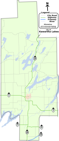
English:
Map of city of
Kawartha Lakes
, with lakes, Ontario King's Highways in dark-blue, and county roads in black.
|
| Date | 31 July 2009 (original upload date)) |
| Source | Own work ( Original text: I ( ʄɭoʏɗiaɲ τ ¢ ) created this work entirely by myself using Flash MX 2004. ) |
| Author | ʄɭoʏɗiaɲ τ ¢ / Floydian at English Wikipedia |
Licensing
Floydian
at
English Wikipedia
, the copyright holder of this work, hereby publishes it under the following licenses:
This file is licensed under the
Creative Commons
Attribution-Share Alike 3.0 Unported
license.
Attribution:
Floydian
at
English Wikipedia
-
You are free:
- to share – to copy, distribute and transmit the work
- to remix – to adapt the work
-
Under the following conditions:
- attribution – You must give appropriate credit, provide a link to the license, and indicate if changes were made. You may do so in any reasonable manner, but not in any way that suggests the licensor endorses you or your use.
- share alike – If you remix, transform, or build upon the material, you must distribute your contributions under the same or compatible license as the original.

|
Permission is granted to copy, distribute and/or modify this document under the terms of the GNU Free Documentation License , Version 1.2 or any later version published by the Free Software Foundation ; with no Invariant Sections, no Front-Cover Texts, and no Back-Cover Texts. A copy of the license is included in the section entitled GNU Free Documentation License . |
You may select the license of your choice.
Original upload log
Transferred from en.wikipedia to Commons by Quadell using CommonsHelper .
The original description page was
here
. All following user names refer to en.wikipedia.
- 2010-02-21 15:27 Floydian 595×1420× (583601 bytes) fix BG colour
- 2010-02-21 15:10 Floydian 595×1420× (583821 bytes) update with standardized colours and shields
- 2009-07-31 19:24 Floydian 595×1420× (279929 bytes) {{Information |Description = Map of city of [[Kawartha Lakes]], with lakes, Ontario King's Highways in dark-blue, and county roads in black. |Source = I (~~~) created this work entirely by myself using Flash MX 2004. |Date = ~~~~~