Indian_village_north_of_Opelousas_on_1820_map_of_Louisiana.jpg

Size of this preview:
323 × 600 pixels
.
Other resolutions:
129 × 240 pixels
|
258 × 480 pixels
|
750 × 1,393 pixels
.
Summary
| Description |
English:
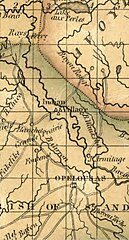
Indian village north of Opelousas on 1820 map of Louisiana may be associated with the Appalousa people
|
| Date | |
| Source |
Title Map of Louisiana Names Melish, John, 1771-1822 Created / Published [Philadelphia] : John Melish, [1820] Headings - Louisiana--Maps - United States--Louisiana Genre Maps Notes - Prime meridian: London and Washington. - Available also through the Library of Congress Web site as a raster image. - Stained throughout. Medium 1 map : hand colored, mounted on cloth ; 53 x 70 cm Call Number/Physical Location G4010 1820 .M4 Repository Library of Congress Geography and Map Division Washington, D.C. 20540-4650 USA dcu Digital Id http://hdl.loc.gov/loc.gmd/g4010.ct003830 Library of Congress Control Number 2013593202 Online Format image LCCN Permalink https://lccn.loc.gov/2013593202 |
| Author | John Melish |
Licensing
|
|
This work is in the
public domain
in the
United States
because it was
published
(or registered with the
U.S. Copyright Office
) before January 1, 1929.
Public domain works must be out of copyright in both the United States and in the source country of the work in order to be hosted on the Commons. If the work is not a U.S. work, the file
must
have an additional
copyright tag
indicating the copyright status in the source country.
Note: This tag should not be used for sound recordings. |