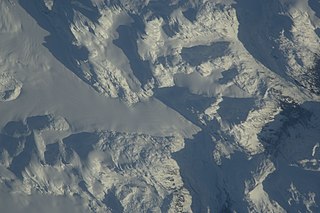
ISS022-E-8455_-_View_of_British_Columbia.jpg

Size of this preview:
800 × 531 pixels
.
Other resolutions:
320 × 213 pixels
|
640 × 425 pixels
|
1,024 × 680 pixels
|
1,280 × 850 pixels
|
2,560 × 1,700 pixels
|
4,288 × 2,848 pixels
.
Summary
| Description |
English:
View of British Columbia taken during ISS Expedition 22.
|
| Date | |
| Source | JSC Gateway to Astronaut Photography of Earth |
| Author | Earth Science and Remote Sensing Unit , Lyndon B. Johnson Space Center |
| Mission | ISS022 |
| Roll | E |
| Frame | 8455 |
| Geographic area | British Columbia |
| Features | PEMBERTON ICEFIELD |
| Cloud percentage | 10% |
| Altitude | 178 nautical miles (330 km) |
| Look angle | 49 |
| Look direction | W |
| Sun Azimuth | 150° |
| Sun Elevation | 11° |
| Camera | Nikon D2Xs Electronic Still Camera |
| Focal length | 800 mm |
| Object location |
|
View this and other nearby images on: OpenStreetMap |
|
|---|
| Camera location |
|
View this and other nearby images on: OpenStreetMap |
|
|---|
|
|
This image or video was catalogued by Johnson Space Center of the United States
National Aeronautics and Space Administration
(NASA) under
Photo ID:
ISS022-E-8455
.
This tag does not indicate the copyright status of the attached work. A normal copyright tag is still required. See Commons:Licensing .
Other languages:
|
Licensing
|
|
This file is in the public domain in the United States because it was solely created by NASA . NASA copyright policy states that "NASA material is not protected by copyright unless noted ". (See Template:PD-USGov , NASA copyright policy page or JPL Image Use Policy .) |
|

|
Warnings:
|