Homelessness_statistics_by_state,_United_States_Interagency_Council_on_Homelessness_(2019).svg

Size of this PNG preview of this SVG file:
750 × 475 pixels
.
Other resolutions:
320 × 203 pixels
|
640 × 405 pixels
|
1,024 × 649 pixels
|
1,280 × 811 pixels
|
2,560 × 1,621 pixels
.
Summary
| Description |
English:
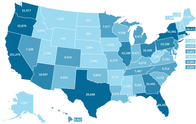
The map below shows state-level estimates of individuals and families experiencing homelessness, based on community point-in-time counts conducted on a given night in January 2019, as reported by Continuums of Care to the U.S. Department of Housing and Urban Development
<1,400
2,801 – 6,200
6,201 – 10,000
10,001 – 13,200
>13,200
|
| Date | |
| Source | https://www.usich.gov/tools-for-action/map/ |
| Author | United States Interagency Council on Homelessness |
| Other versions |
|
| SVG development |
.png)
Licensing
|
|
This work is in the
public domain
in the United States because it is a
work prepared by an officer or employee of the United States Government as part of that person’s official duties
under the terms of
Title 17, Chapter 1, Section 105
of the
US Code
.
Note
: This only applies to original works of the Federal Government and not to the work of any individual
U.S. state
,
territory
, commonwealth, county, municipality, or any other subdivision. This template also does not apply to postage stamp designs published by the
United States Postal Service
since 1978
. (See §
313.6(C)(1)
of Compendium of U.S. Copyright Office Practices). It also does not apply to certain US coins; see
The US Mint Terms of Use
.
|

|
| This file has been identified as being free of known restrictions under copyright law, including all related and neighboring rights. | ||