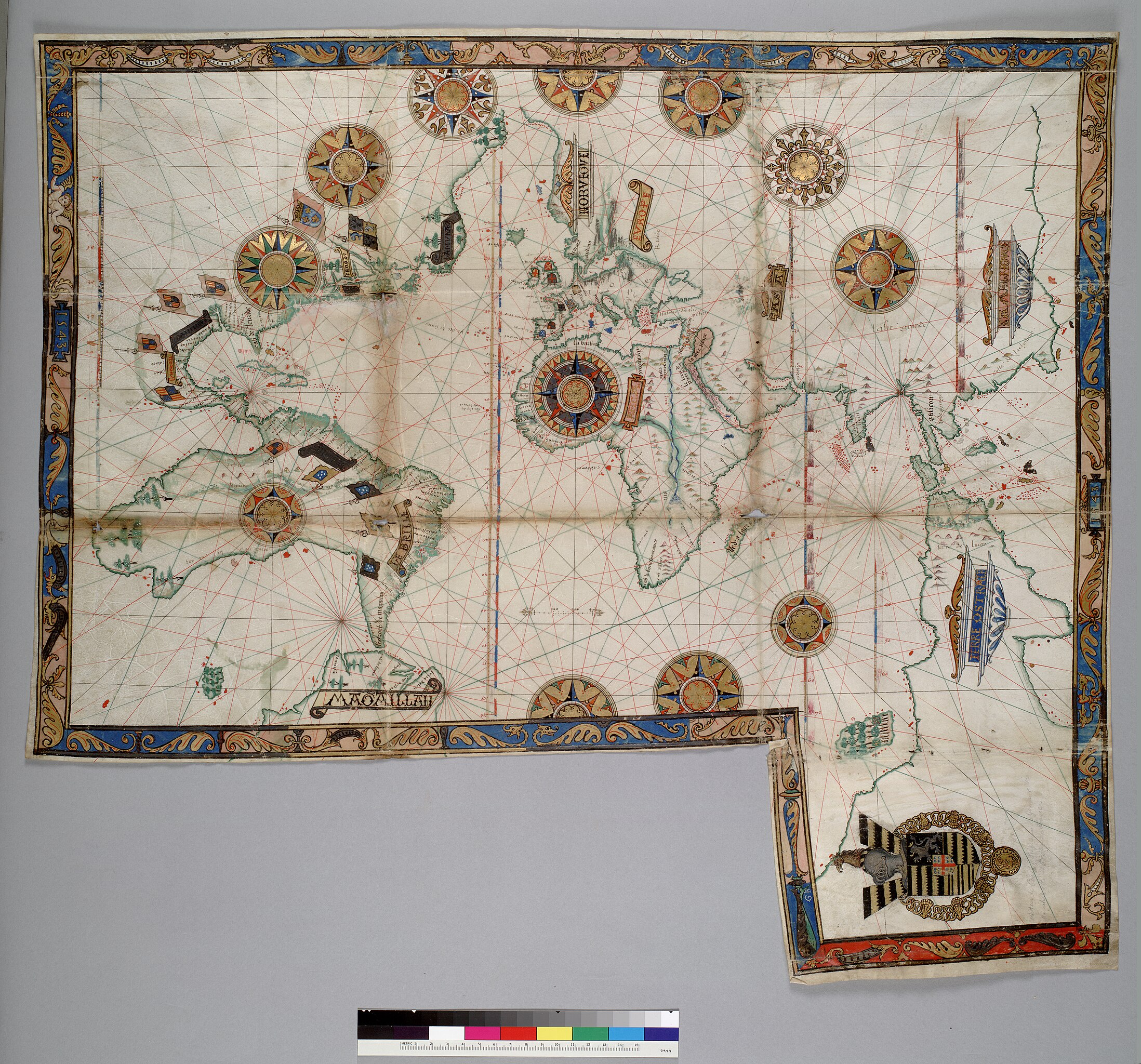
Guillaume_Brouscon._World_chart,_which_includes_America_and_a_large_Terra_Java_(Australia)._HM_46._PORTOLAN_ATLAS_and_NAUTICAL_ALMANAC._France,_1543.jpg

Size of this preview:
643 × 600 pixels
.
Other resolutions:
257 × 240 pixels
|
515 × 480 pixels
|
824 × 768 pixels
|
1,098 × 1,024 pixels
|
2,196 × 2,048 pixels
|
8,497 × 7,924 pixels
.
| Warning | The original file is very high-resolution. It might not load properly or could cause your browser to freeze when opened at full size. |
|---|
Summary
| Description |
English:
World chart, which includes America and a large promontory of the "Terre Ostrale" (
Terra Australis
) inscribed in its northern part
terre de lucac
(
Locach
). HM 46. PORTOLAN ATLAS and NAUTICAL ALMANAC. France, 1543.
Call Number
: HM 46
|
||||||||||||||||
| Date | |||||||||||||||||
| Source | berkeley.edu | ||||||||||||||||
| Author |
|
||||||||||||||||
| Other versions |
W. A. R. Richardson.
Was Australia charted before 1606?
: the Java la Grande inscriptions
. P. 37
|
||||||||||||||||
._HM_46._PORTOLAN_ATLAS_and_NAUTICAL_ALMANAC._France,_1543_(cropped).jpg)
._HM_46._PORTOLAN_ATLAS_and_NAUTICAL_ALMANAC._France,_1543_(cropped).jpg)
._HM_46._PORTOLAN_ATLAS_and_NAUTICAL_ALMANAC._France,_1543_(cropped).jpg)
._HM_46._PORTOLAN_ATLAS_and_NAUTICAL_ALMANAC._France,_1543_(cropped).jpg)
._HM_46._PORTOLAN_ATLAS_and_NAUTICAL_ALMANAC._France,_1543_(cropped).jpg)
._HM_46._PORTOLAN_ATLAS_and_NAUTICAL_ALMANAC._France,_1543.A.jpg)
._HM_46._PORTOLAN_ATLAS_and_NAUTICAL_ALMANAC._France,_1543.B.jpg)
._HM_46._PORTOLAN_ATLAS_and_NAUTICAL_ALMANAC._France,_1543.C.jpg)
Source
berkeley.edu archive copy at the Wayback Machine
Licensing
|
This is a faithful photographic reproduction of a two-dimensional,
public domain
work of art. The work of art itself is in the public domain for the following reason:
The official position taken by the Wikimedia Foundation is that "
faithful reproductions of two-dimensional public domain works of art are public domain
".
This photographic reproduction is therefore also considered to be in the public domain in the United States. In other jurisdictions, re-use of this content may be restricted; see Reuse of PD-Art photographs for details. |
||||