Great_Lakes_from_space.jpg

Size of this preview:
800 × 485 pixels
.
Other resolutions:
320 × 194 pixels
|
640 × 388 pixels
|
900 × 546 pixels
.
Summary
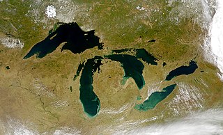
| Description | Satellite image of the Great Lakes from space |
| Date | |
| Source | http://visibleearth.nasa.gov/view_rec.php?id=793 |
| Author | SeaWiFS Project, NASA/Goddard Space Flight Center, and ORBIMAGE. |
| Other versions |


|
Licensing
|
|
This image is from the Sea-viewing Wide Field-of-view Sensor (
SeaWiFS
) Project and more than 5 years old.
Satellite data captured by the SeaWIFS sensor are released into the public domain 5 years after capture. Data less than five years old can be re-used only for educational or scientific purposes; any commercial use of such images must be coordinated with GeoEye . [1] |
|
|
This work has been released into the
public domain
by its
copyright
holder,
GeoEye
. This applies worldwide.
In some countries this may not be legally possible; if so: GeoEye grants anyone the right to use this work for any purpose , without any conditions, unless such conditions are required by law.
|