Great_Basin_map.gif

Size of this preview:
537 × 600 pixels
.
Other resolutions:
215 × 240 pixels
|
430 × 480 pixels
|
687 × 768 pixels
|
1,074 × 1,200 pixels
.
Summary
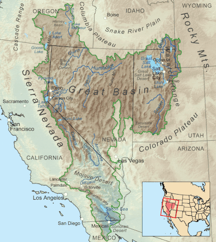
| Description | Map showing the Great Basin drainage basin as defined hydrologically. |
| Date | (UTC) |
| Source |
This file was derived from:
Greatbasinmap.png
:

|
| Author |
|
Licensing
Kmusser
at
Wikimedia Commons
, the copyright holder of this work, hereby publishes it under the following license:
This file is licensed under the
Creative Commons
Attribution-Share Alike 3.0 Unported
license.
Attribution:
Kmusser
at
Wikimedia Commons
-
You are free:
- to share – to copy, distribute and transmit the work
- to remix – to adapt the work
-
Under the following conditions:
- attribution – You must give appropriate credit, provide a link to the license, and indicate if changes were made. You may do so in any reasonable manner, but not in any way that suggests the licensor endorses you or your use.
- share alike – If you remix, transform, or build upon the material, you must distribute your contributions under the same or compatible license as the original.
Original upload log
This image is a derivative work of the following images:
-
File:Greatbasinmap.png
licensed with Cc-by-sa-3.0
- 2020-09-04T22:25:15Z Nwbeeson 1500x1676 (7565343 Bytes) Added boundary map. Second attempt to upload the image.
- 2020-09-04T22:21:06Z Nwbeeson 1500x1676 (7564895 Bytes) Added boundary line.
- 2010-12-11T16:58:55Z Kmusser 1500x1676 (3820728 Bytes) Added Goose Lake
- 2010-11-17T20:37:07Z Kmusser 1500x1676 (3382394 Bytes) == Summary == {{Information |Description=Map showing the [[:w:Great Basin|Great Basin]] drainage basin as defined hydrologically. |Source={{own}}, Elevation data from [[:w:Shuttle Radar Topography Mission|SRTM]], all other fe
Uploaded with derivativeFX