Glenrothes_with_Thornton_railway_station_-_geograph.org.uk_-_946078.jpg
No higher resolution available.
Summary
| Description |
English:
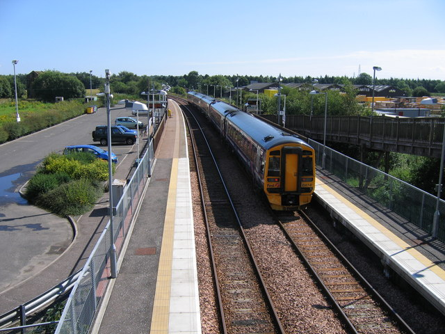
Glenrothes with Thornton railway station Viewed from Main Street bridge, Thornton, a five-coach Fife Circle train stands at Platform 1, waiting to depart for Edinburgh via Kirkcaldy. Although apparently a conventional double-track station, things are not quite what they seem. Most Fife Circle trains use Platform 1 in both directions. Platform 2 is used only by a few trains in the peak periods, running to or from Markinch and Perth. The two tracks diverge respectively south and north round the curve in the background. Immediately east of Main Street bridge crossovers between the two tracks mark the start of normal Up and Down double track. In the left background, half-hidden behind a bush, is the derelict winding house of a former coal pit.
|
| Date | |
| Source | From geograph.org.uk |
| Author | A-M-Jervis |
|
Attribution
( required by the license ) |
A-M-Jervis / Glenrothes with Thornton railway station / |
| Camera location |
|
View this and other nearby images on: OpenStreetMap |
|
|---|
_heading:90.00&language=en)
| Object location |
|
View this and other nearby images on: OpenStreetMap |
|
|---|
_heading:90.00&language=en)
Licensing

|
This image was taken from the
Geograph project
collection. See
this photograph's page
on the Geograph website for the photographer's contact details. The copyright on this image is owned by
A-M-Jervis
and is licensed for reuse under the
Creative Commons
Attribution-ShareAlike 2.0 license.
|
This file is licensed under the
Creative Commons
Attribution-Share Alike 2.0 Generic
license.
Attribution:
A-M-Jervis
-
You are free:
- to share – to copy, distribute and transmit the work
- to remix – to adapt the work
-
Under the following conditions:
- attribution – You must give appropriate credit, provide a link to the license, and indicate if changes were made. You may do so in any reasonable manner, but not in any way that suggests the licensor endorses you or your use.
- share alike – If you remix, transform, or build upon the material, you must distribute your contributions under the same or compatible license as the original.