Gaza_flotilla_raid_map.svg

Size of this PNG preview of this SVG file:
783 × 600 pixels
.
Other resolutions:
314 × 240 pixels
|
627 × 480 pixels
|
1,003 × 768 pixels
|
1,280 × 980 pixels
|
2,560 × 1,960 pixels
|
1,148 × 879 pixels
.
| Description |
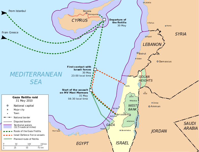
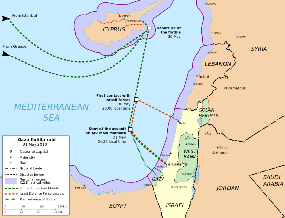
English:
Freedom Flotilla incident. 31 may 2010. Cartographic base from Open Street Maps (heavily modified) Flotilla route points from
Freegaza.org
(under CC by-sa)
Español:
Ataque a la Flotilla Libertad (ó Flotilla de Gaza) el 31 de mayo de 2010. Base cartográfica de Open Street Maps (muy modificada) Puntos de la ruta de la Flotilla
Freegaza.org
(bajo licencia CC by-sa)
|
| Date | (UTC) |
| Source | |
| Author |
|
| Other versions | العربيَّة |
|
|
This is a
retouched picture
, which means that it has been digitally altered from its original version. Modifications:
Translation into English
. The original can be viewed here:
Flotillagazamapa.svg
:
|
I, the copyright holder of this work, hereby publish it under the following licenses:
This file is licensed under the
Creative Commons
Attribution-Share Alike
3.0 Unported
,
2.5 Generic
,
2.0 Generic
and
1.0 Generic
license.
-
You are free:
- to share – to copy, distribute and transmit the work
- to remix – to adapt the work
-
Under the following conditions:
- attribution – You must give appropriate credit, provide a link to the license, and indicate if changes were made. You may do so in any reasonable manner, but not in any way that suggests the licensor endorses you or your use.
- share alike – If you remix, transform, or build upon the material, you must distribute your contributions under the same or compatible license as the original.

|
Permission is granted to copy, distribute and/or modify this document under the terms of the GNU Free Documentation License , Version 1.2 or any later version published by the Free Software Foundation ; with no Invariant Sections, no Front-Cover Texts, and no Back-Cover Texts. A copy of the license is included in the section entitled GNU Free Documentation License . |
You may select the license of your choice.
Original upload log
This image is a derivative work of the following images:
-
File:Flotillagazamapa.svg
licensed with Cc-by-sa-3.0,2.5,2.0,1.0, GFDL
- 2010-06-15T22:47:28Z Montgomery 1148x879 (834154 Bytes) Golan Heights (Altos del Golán) painted with stripes. Hour adjust.
- 2010-06-10T13:59:40Z Montgomery 1148x879 (833375 Bytes) Adjust of territorial waters limits. Exclude contiguous zone.
- 2010-06-09T23:28:19Z Montgomery 1148x879 (845333 Bytes) Map colours conventions & minor changes.
- 2010-06-07T14:40:55Z Montgomery 1148x879 (939230 Bytes) minor changes
- 2010-06-07T13:01:02Z Rastrojo 1148x879 (1047421 Bytes) fixing
- 2010-06-06T20:32:24Z Montgomery 1148x879 (1040381 Bytes) {{Information |Description={{en|1=Freedom Flotilla incident. 31 may 2010. Cartographic base from Open Street Maps (heavily modified) Flotilla route points from [http://www.witnessgaza.com/ Freegaza.org] (under CC by-sa)}} {{e
Uploaded with derivativeFX