French_Guiana_CIA.gif
No higher resolution available.
Summary
| Description |
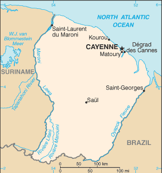
English:
Map of
French Guiana
|
| Source |
Taken from the
CIA
World Factbook
web site on
|
| Author |
Licensing
|
|
This image is in the
public domain
because it contains materials that originally came from the United States
Central Intelligence Agency
's
World Factbook
.
|

|
Original upload log
The original description page was
here
. All following user names refer to en.wikipedia.
- 2006-01-18 08:54 Hoshie 329×352× (11208 bytes) Updated map of French Guiana from CIA website, 10 January 2006
- 2005-12-22 22:31 Eric Shalov 330×355× (8264 bytes) == Summary == Map of [[French Guiana]] taken from the [[CIA]] [http://www.cia.gov/cia/publications/factbook/maps/fg-map.gif World Factbook] web site on [[December 22]], [[2005]].