Four_Corners_monument_(Canada).jpg

Size of this preview:
332 × 599 pixels
.
Other resolutions:
133 × 240 pixels
|
266 × 480 pixels
|
712 × 1,284 pixels
.
Summary
| Description |
English:
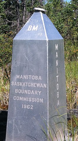
The
obelisk
monument marking the
intersection
of Manitoba, Saskatchewan, Northwest Territories, and hypothetically Nunavut. The face reading "Manitoba Saskatchewan Boundary Commission 1962", faces the Manitoba-Saskatchewan border to the south. The "BM" stands for the bench mark on the top.
|
| Date | |
| Source | File:4 Corners, Canada, Obelisk.jpg |
| Author | Own work |
| Object location |
|
View this and other nearby images on: OpenStreetMap |
|
|---|

.jpg¶ms=059.999442_N_-102.007567_E_globe:Earth_class:object_type:object_region:CA_&language=en)
Licensing
I, the copyright holder of this work, hereby publish it under the following license:
This file is licensed under the
Creative Commons
Attribution-Share Alike 3.0 Unported
license.
-
You are free:
- to share – to copy, distribute and transmit the work
- to remix – to adapt the work
-
Under the following conditions:
- attribution – You must give appropriate credit, provide a link to the license, and indicate if changes were made. You may do so in any reasonable manner, but not in any way that suggests the licensor endorses you or your use.
- share alike – If you remix, transform, or build upon the material, you must distribute your contributions under the same or compatible license as the original.