Former_town_hall_Westzaan.jpg

Size of this preview:
800 × 533 pixels
.
Other resolutions:
320 × 213 pixels
|
640 × 427 pixels
|
1,050 × 700 pixels
.
|
|
This is an image of
rijksmonument
number
40005
Information from structured data : |
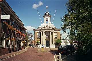
Photograph of the former town hall of the Dutch village of Westzaan (now part of the municipality of Zaanstad). Construction took place from 1781 to 1783 under architect Jacob S. Creutz. The Louis XVI style building was used as court until 1816, then as town hall until 1974. At the time of the photograph, the building was owned by a foundation and was a state monument.
Copyright situation
This photograph was made on August 28 2004 by the uploader. It is provided under two licenses: GFDL and public domain. The latter implies that it may be used, distributed and modified without cost and without attribution or any other obligation.

|
Permission is granted to copy, distribute and/or modify this document under the terms of the GNU Free Documentation License , Version 1.2 or any later version published by the Free Software Foundation ; with no Invariant Sections, no Front-Cover Texts, and no Back-Cover Texts. A copy of the license is included in the section entitled GNU Free Documentation License . |
|
|
This file is licensed under the Creative Commons Attribution-Share Alike 3.0 Unported license. | |
|
||
| This licensing tag was added to this file as part of the GFDL licensing update . |
|
|
I, the copyright holder of this work, release this work into the
public domain
. This applies worldwide.
In some countries this may not be legally possible; if so: I grant anyone the right to use this work for any purpose , without any conditions, unless such conditions are required by law. |
| Object location |
|
View this and other nearby images on: OpenStreetMap |
|
|---|