Forlorn_Hope_Estate,_1828.jpg

Size of this preview:
800 × 595 pixels
.
Other resolutions:
320 × 238 pixels
|
640 × 476 pixels
|
1,024 × 762 pixels
|
1,280 × 953 pixels
|
2,560 × 1,905 pixels
|
3,765 × 2,802 pixels
.
Summary
| Description |
English:
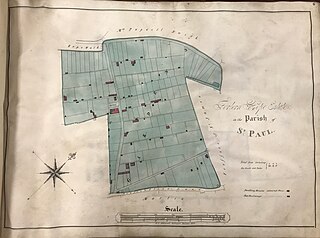
A plan or map of a property holding in Bristol, England, owned at the time by a charitable trust called St Nicholas Church Lands: “Volume of plans of St Nicholas Church Lands, 1828’, Bristol Archives, 39180, p. 6.
|
| Date | |
| Source | https://archive.org/details/beardplague/page/27/mode/2up |
| Author | George C. Ashmead |
| Camera location |
|
View this and other nearby images on: OpenStreetMap |
|
|---|
First published in: Alex Beard (ed.), Documents Relating to the Great Plague of 1665-1666 in Bristol (Bristol Record Society electronic publication, September 2021), p. 27
Licensing
|
|
This work is in the public domain in its country of origin and other countries and areas where the copyright term is the author's life plus 70 years or fewer . This work is in the public domain in the United States because it was published (or registered with the U.S. Copyright Office ) before January 1, 1929. |
| This file has been identified as being free of known restrictions under copyright law, including all related and neighboring rights. | |