Etosha_Springbock.jpg

Size of this preview:
600 × 600 pixels
.
Other resolutions:
240 × 240 pixels
|
480 × 480 pixels
|
768 × 768 pixels
|
1,024 × 1,024 pixels
|
2,467 × 2,467 pixels
.
| Description |
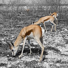
Afrikaans:
Springbokke weiend in gebrande veld, Nasionale Etoshawildtuin
Deutsch:
Springböcke suchen in der abgebrannten Savanne Nahrung
|
| Date | |
| Source | Own work |
| Author | Ikiwaner |
|
Permission
( Reusing this file ) |
GNU Free Documentation License v1.2 only |
| Camera location |
|
View this and other nearby images on: OpenStreetMap |
|
|---|
|
|
This is a
retouched picture
, which means that it has been digitally altered from its original version. Modifications:
Der Effekt, dass die Springböcke als Farbtupfer in der Schwarzweissen Landschaft hervortreten wurde mit einer Sättigungs-Einstellebene mit Maske verstärkt.
.
|

|
Permission is granted to copy, distribute and/or modify this document under the terms of the GNU Free Documentation License , Version 1.2 only as published by the Free Software Foundation ; with no Invariant Sections, no Front-Cover Texts, and no Back-Cover Texts. A copy of the license is included in the section entitled GNU Free Documentation License . | 1.2 only |
|
|
This image has been assessed using the
Quality image guidelines
and is considered a
Quality image
.
|