Eq-prob.jpg
Size of this preview:
448 × 600 pixels
.
Other resolutions:
179 × 240 pixels
|
535 × 716 pixels
.
Summary
| Description |
English:
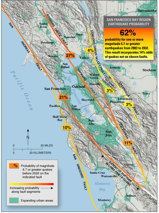
USGS
seismic hazard map showing the probability of an M6.7 or greater earthquake occurring in the
San Francisco Bay Area
between
2003
and
2032
.
Recent (January 2008) assessments (San Jose Mercury News:
Hayward fault might be more dangerous than scientists thought
) suggest that the
Hayward
, Rodgers Creek, and northern
Calaveras
faults may be more likely to fail in the next few decades than previously thought (more so than is indicated on this map).
|
| Source | https://pubs.usgs.gov/fs/old.2003/fs039-03/ |
| Author |
Licensing
|
|
This image is in the
public domain
in the United States because it only contains materials that originally came from the
United States Geological Survey
, an agency of the
United States Department of the Interior
. For more information, see
the official USGS copyright policy
.
|
|
Original upload log
The original description page was
here
. All following user names refer to en.wikipedia.
- 2005-05-04 07:16 RockBandit 535×716×8 (153090 bytes) [[USGS]] seismic hazard map showing the probability of a M6.7 or greater earthquake occuring in the [[San Francisco Bay Area]] between [[2003]] and [[2032]]. {{PD-USGov-Interior-USGS}}