Electoral_district_of_Lara_(Victoria)_2022.svg

Size of this PNG preview of this SVG file:
800 × 568 pixels
.
Other resolutions:
320 × 227 pixels
|
640 × 454 pixels
|
1,024 × 727 pixels
|
1,280 × 909 pixels
|
2,560 × 1,818 pixels
.
Summary
| Description |
English:
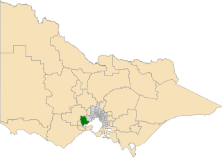
Location and boundaries of the electoral district (dark green) in the state of Victoria, Australia after the 2021 redistribution to be used in the 2022 Victorian state election scheduled to be held on 26 November 2022. Shapefile from
https://www.ebc.vic.gov.au/CurrentRedivision/Resources.html
New electoral districts and regions (spatial data - shapefile)
(© Electoral Boundaries Commission 2020, provided under a Creative Commons Attribution 4.0 international licence).
|
| Date | |
| Source | Own work |
| Author | Twotwofourtysix |
Licensing
I, the copyright holder of this work, hereby publish it under the following license:
This file is licensed under the
Creative Commons
Attribution 4.0 International
license.
-
You are free:
- to share – to copy, distribute and transmit the work
- to remix – to adapt the work
-
Under the following conditions:
- attribution – You must give appropriate credit, provide a link to the license, and indicate if changes were made. You may do so in any reasonable manner, but not in any way that suggests the licensor endorses you or your use.