EU_Pop2008_1024.PNG

Size of this preview:
600 × 599 pixels
.
Other resolutions:
240 × 240 pixels
|
481 × 480 pixels
|
769 × 768 pixels
|
1,025 × 1,024 pixels
|
1,536 × 1,534 pixels
.

|
This
demographic map
image could be re-created
using
vector graphics
as an
SVG
file
. This has several advantages; see
Commons:Media for cleanup
for more information. If an SVG form of this image is available, please upload it and afterwards replace this template with
{{

vector version available

|

new image name

}}
.
It is recommended to name the SVG file “EU Pop2008 1024.svg”—then the template Vector version available (or Vva ) does not need the new image name parameter. |
Summary
| Description |
English:
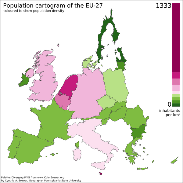
A preliminary population cartogram of the EU-27 made with
ScapeToad 1.1
using a cut-down and reprojected public domain world shapefile (projection: Lambert Azimuthal Equal Area) and January 2008 population data from Eurostat. This version includes Dutch barrier islands.
|
| Date | |
| Source | Own work |
| Author | Vinny Burgoo |
| Other versions | Derivative works of this file: EU Pop2008 1024 new.png |
See also Geoilex's EU cartogram .
Licensing
|
|
I, the copyright holder of this work, release this work into the
public domain
. This applies worldwide.
In some countries this may not be legally possible; if so: I grant anyone the right to use this work for any purpose , without any conditions, unless such conditions are required by law. |