Depsang-Bulge-mouth-2020.jpg

Size of this preview:
800 × 351 pixels
.
Other resolutions:
320 × 140 pixels
|
640 × 281 pixels
|
1,364 × 598 pixels
.
Summary
| Description |
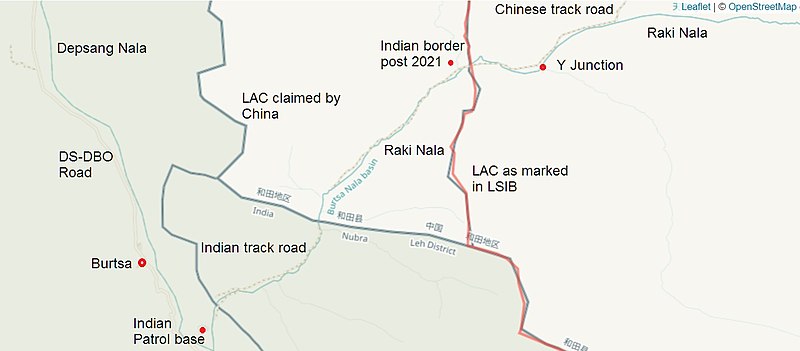
English:
Close-up map of the mouth of
Depsang Bulge
near
Burtsa
in 2020. US
Office of the Geographer
LSIB border shown in red.
|
| Date | |
| Source | https://data.humdata.org/dataset/large-scale-international-boundaries-lsib |
| Author | Contributors to OpenStreetMap, US Office of the Geographer |
| Other versions |
Overview of the Depsang Bulge

|
Licensing
This file is licensed under the
Creative Commons
Attribution-Share Alike 2.0 Generic
license.
-
You are free:
- to share – to copy, distribute and transmit the work
- to remix – to adapt the work
-
Under the following conditions:
- attribution – You must give appropriate credit, provide a link to the license, and indicate if changes were made. You may do so in any reasonable manner, but not in any way that suggests the licensor endorses you or your use.
- share alike – If you remix, transform, or build upon the material, you must distribute your contributions under the same or compatible license as the original.
|
|
This work is licensed under the Open Database License ( summary ). |
|
|
This file is a work of a
U.S. Army
soldier or employee, taken or made as part of that person's official duties. As a
work
of the
U.S. federal government
, it is in the
public domain
in the United States.
|

|