December_16–17,_2019_tornado_outbreak_warnings_and_reports.png

Size of this preview:
800 × 566 pixels
.
Other resolutions:
320 × 226 pixels
|
640 × 453 pixels
|
1,024 × 724 pixels
|
1,280 × 905 pixels
|
2,560 × 1,810 pixels
|
3,507 × 2,480 pixels
.
Summary
| Description |
English:
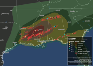
Map of tornado warnings issued by the National Weather Service between December 16 and December 17, 2019, over the southern United States and tornadoes confirmed and surveyed by the National Weather Service overlaid on a GOES-East infrared brightness temperature image from 23:59 UTC on December 16. Map produced in QGIS with border outlines from the United States Census Bureau. National Weather Service warning outlines available from the Iowa Environmental Mesonet and tornado data available from the National Weather Service. GOES-East imagery from the University of Wisconsin-Madison courtesy of NASA/NOAA.
|
| Date | |
| Source | Own work |
| Author | TheAustinMan |
Licensing
I, the copyright holder of this work, hereby publish it under the following license:
This file is licensed under the
Creative Commons
Attribution-Share Alike 4.0 International
license.
-
You are free:
- to share – to copy, distribute and transmit the work
- to remix – to adapt the work
-
Under the following conditions:
- attribution – You must give appropriate credit, provide a link to the license, and indicate if changes were made. You may do so in any reasonable manner, but not in any way that suggests the licensor endorses you or your use.
- share alike – If you remix, transform, or build upon the material, you must distribute your contributions under the same or compatible license as the original.