Dall_Island_and_Cordova_Bay_from_space.JPG

Size of this preview:
800 × 530 pixels
.
Other resolutions:
320 × 212 pixels
|
640 × 424 pixels
|
1,024 × 678 pixels
|
1,280 × 848 pixels
|
3,032 × 2,008 pixels
.
Summary
| Description |
English:
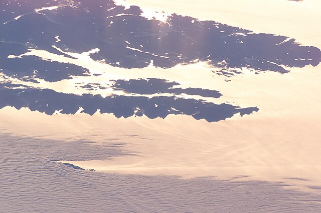
Dall island and Cordova Bay photographed from earth orbit, high oblique. NASA data at
http://eol.jsc.nasa.gov/scripts/sseop/photo.pl?mission=ISS011&roll=E&frame=9027
.
Looking toward the sunrise, a bit north of east. Water appears bright due to sun glint. Dall Island, Long Island, and most of Sukkwan island are visible as dark areas in the middle of the picture, while the land near the top of the picture is Prince of Wales Island. The small island at lower left is Forrester Island.
|
| Date | |
| Source | Image courtesy of the Image Science & Analysis Laboratory, NASA Johnson Space Center ISS011-E-9027 ftp://eol.jsc.nasa.gov/ESC_large_ISS011_ISS011-E-9027.JPG |
| Author | NASA |
Center Point Latitude: 54.9 Center Point Longitude: -132.7
Licensing
|
|
This file is in the public domain in the United States because it was solely created by NASA . NASA copyright policy states that "NASA material is not protected by copyright unless noted ". (See Template:PD-USGov , NASA copyright policy page or JPL Image Use Policy .) |
|

|
Warnings:
|