DC_neighborhoods_map.png

Size of this preview:
526 × 599 pixels
.
Other resolutions:
211 × 240 pixels
|
421 × 480 pixels
|
674 × 768 pixels
|
899 × 1,024 pixels
|
1,493 × 1,700 pixels
.
Summary
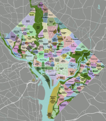
| Description | DC neighborhoods map |
| Date | |
| Source | self-made, tracing done from PD satellite imagery |
| Author | Peter Fitzgerald |
|
Permission
( Reusing this file ) |
CC-by 3.0 |
| Other versions | SVG available on Wikitravel Shared , although it is not the current version, as Shared has a 8MB filesize limit... |
|
Need a higher resolution version? There's one available at File:DC neighborhoods map high res.png . (The thumbnail does not display images at such a high resolution—to access the file, click the "Full resolution" link [1] below the broken thumbnail.) |
![[1]](https://upload.wikimedia.org/wikipedia/commons/b/b8/DC_neighborhoods_map_high_res.png)
Licensing
I, the copyright holder of this work, hereby publish it under the following license:
This file is licensed under the
Creative Commons
Attribution 3.0 Unported
license.
-
You are free:
- to share – to copy, distribute and transmit the work
- to remix – to adapt the work
-
Under the following conditions:
- attribution – You must give appropriate credit, provide a link to the license, and indicate if changes were made. You may do so in any reasonable manner, but not in any way that suggests the licensor endorses you or your use.

|
This
locator map
image could be re-created
using
vector graphics
as an
SVG
file
. This has several advantages; see
Commons:Media for cleanup
for more information. If an SVG form of this image is available, please upload it and afterwards replace this template with
{{

vector version available

|

new image name

}}
.
It is recommended to name the SVG file “DC neighborhoods map.svg”—then the template Vector version available (or Vva ) does not need the new image name parameter. |