Cocos_(Keeling)_Islands-CIA_WFB_Map.png
No higher resolution available.
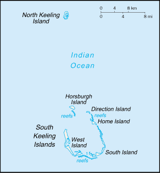
| Description |
English:
A map of Cocos (Keeling) Islands.
Русский:
Карта Кокосовых (Килинг) островов
|
|||
| Source | https://www.cia.gov/library/publications/the-world-factbook/maps/ck-map.gif | |||
| Author | CIA World Factbook | |||
|
Permission
( Reusing this file ) |
|


|
This
map
image could be re-created
using
vector graphics
as an
SVG
file
. This has several advantages; see
Commons:Media for cleanup
for more information. If an SVG form of this image is available, please upload it and afterwards replace this template with
{{

vector version available

|

new image name

}}
.
It is recommended to name the SVG file “Cocos (Keeling) Islands-CIA WFB Map.svg”—then the template Vector version available (or Vva ) does not need the new image name parameter. |