Cheneso_2023-01-25_1100Z.jpg

Size of this preview:
462 × 599 pixels
.
Other resolutions:
185 × 240 pixels
|
370 × 480 pixels
|
592 × 768 pixels
|
789 × 1,024 pixels
|
1,579 × 2,048 pixels
|
3,700 × 4,800 pixels
.
Summary
| Description |
English:
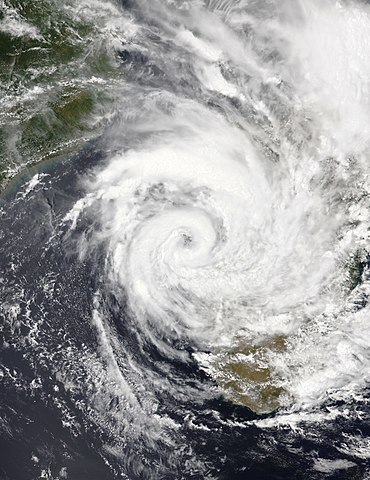
This true-color image of Tropical Cyclone Cheneso was captured on the afternoon of 25 January 2023, at 11:00 UTC or (2:00 PM Madagascar Local time), by the Visible Infrared Imaging Radiometer Suite (VIIRS) instrument flying aboard NASA/NOAA's NOAA-20 satellite. Cheneso was a moderately strong cyclone and heavy rain producer that originated from a tropical disturbance east of Madagascar during the 2022-23 South-West Indian Ocean cyclone season in mid-January 2023. When this image was captured, Cheneso was nearly stationary over the Mozambique channel just off the west coast of Madagascar, where it delivered flooding rains in the country. Cheneso killed at least 25 people, and its damages are unknown as of now. When this was captured, Cheneso was intensifying as a Category 1 equivalent cyclone, with winds of 80 mph (130 km/h) (70 knots) on the 1-min Saffir-Simpson scale and winds of 75 mph (121 km/h) (65 knots) on the 10-min MFR cyclone scale making it a "tropical cyclone" on that scale. It had a minimum central pressure of 973 mbar (28.7 inHg), and it would ultimately reach its peak intensity around 12 hours later during the evening to night hours.
|
| Date | |
| Source | EOSDIS Worldview |
| Author | NASA/NOAA-20 |
Licensing
|
|
This file is in the public domain in the United States because it was solely created by NASA . NASA copyright policy states that "NASA material is not protected by copyright unless noted ". (See Template:PD-USGov , NASA copyright policy page or JPL Image Use Policy .) |
|

|
Warnings:
|