I, the copyright holder of this work, release this work into the
public domain
. This applies worldwide.
In some countries this may not be legally possible; if so:
I grant anyone the right to use this work
for any purpose
, without any conditions, unless such conditions are required by law.
This work has been released into the
public domain
by its author,
Aimelaime
at
French Wikipedia
. This applies worldwide.
In some countries this may not be legally possible; if so:
Aimelaime
grants anyone the right to use this work
for any purpose
, without any conditions, unless such conditions are required by law.
Public domain
Public domain
false
false
Original upload log
The original description page was
here
. All following user names refer to fr.wikipedia.
2011-09-30 15:02
Aimelaime
3000×4000× (1945781 bytes)
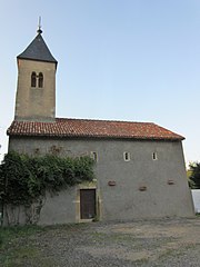
{{Information |Description = chapelle Vantoux |Source = mon appareil photo |Date = 30 septembre 2011 |Auteur = Aimelaime |Permission = {{PD-self }} }} <!--Merci d'ajouter au moins une catégorie. Exemple : [[Catégorie:Image sur Wikipédia]]-->
Captions
Add a one-line explanation of what this file represents
