Cascade_Range_map.png

Size of this preview:
455 × 599 pixels
.
Other resolutions:
182 × 240 pixels
|
473 × 623 pixels
.
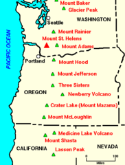
| Description | Major Cascade Range Volcanoes: the Cascade Range is a volcanic chain stretching from northern California to British Columbia | |||
| Date | ||||
| Source | Archived source link | |||
| Author | Lyn Topinka, USGS; modified from Tilling, et al., 1990 | |||
|
Permission
( Reusing this file ) |
|
|||
| Other versions |

|
