Cape_Tormentine_Outer_Wharf.jpg

Size of this preview:
800 × 547 pixels
.
Other resolutions:
320 × 219 pixels
|
640 × 437 pixels
|
1,024 × 700 pixels
|
1,280 × 875 pixels
|
2,560 × 1,749 pixels
|
4,391 × 3,000 pixels
.
Summary
| Description |
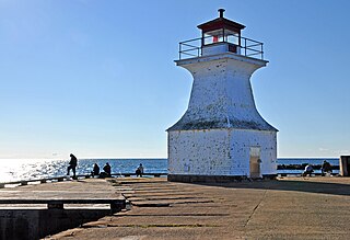
Cape Tormentine Outer Wharf. The present front light, a short pepper-pot style tower, was put in place in the 1940s. Cape Tormentine is the easternmost point in New Brunswick. After the completion of the Federation Bridge in 1997, the Cape Tormentine – Borden Ferry was discontinued, and with it, so were the Cape Tormentine Pier Range Lights. At the request of local fishermen, who still use the harbour, the front light was reactivated in 1998. The Canadian Coast Guard maintains the front light in good condition. It is now declared surplus by the Canadian Government. Link to the surplus list: www.dfo-mpo.gc.ca/media/infocus-alaune/2010/02/index-eng.htm |
| Date | |
| Source |
DGJ_8442 - Cape Tormentine Outer Wharf
|
| Author | Dennis Jarvis from Halifax, Canada |
| Camera location |
|
View this and other nearby images on: OpenStreetMap |
|
|---|
Licensing
This file is licensed under the
Creative Commons
Attribution-Share Alike 2.0 Generic
license.
-
You are free:
- to share – to copy, distribute and transmit the work
- to remix – to adapt the work
-
Under the following conditions:
- attribution – You must give appropriate credit, provide a link to the license, and indicate if changes were made. You may do so in any reasonable manner, but not in any way that suggests the licensor endorses you or your use.
- share alike – If you remix, transform, or build upon the material, you must distribute your contributions under the same or compatible license as the original.
|
|
This image, originally posted to Flickr , was reviewed on 5 May 2012 by the administrator or reviewer File Upload Bot (Magnus Manske) , who confirmed that it was available on Flickr under the stated license on that date. |