C74112s5_Ant.Map_Martin_Peninsula.jpg

Size of this preview:
581 × 599 pixels
.
Other resolutions:
233 × 240 pixels
|
465 × 480 pixels
|
745 × 768 pixels
|
993 × 1,024 pixels
|
1,985 × 2,048 pixels
|
3,621 × 3,735 pixels
.
Summary
| Description |
English:
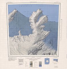
1:250,000-scale topographic reconnaissance map of the Martin Peninsula area from 112°30'-117°W to 73°45'-75°S in Antarctica, including the eastern parts of the Getz Ice Shelf and the western parts of Dotson Ice Shelf. Mapped, edited and published by the U.S. Geological Survey in cooperation with the National Science Foundation.
|
|||
| Date | ||||
| Source | http://usarc.usgs.gov/drg_dload.shtml | |||
| Author | United States Geological Survey | |||
|
Permission
( Reusing this file ) |
|