Bugatti_Circuit.svg

Size of this PNG preview of this SVG file:
800 × 395 pixels
.
Other resolutions:
320 × 158 pixels
|
640 × 316 pixels
|
1,024 × 506 pixels
|
1,280 × 632 pixels
|
2,560 × 1,265 pixels
|
1,423 × 703 pixels
.
Summary
| Description |
English:
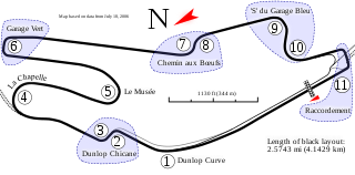
Track map for the
Bugatti Circuit
. Created with Inkscape. The full 24 Hours of Le Mans circuit is shown in gray with black dots.
|
| Date | 6-1-2008 |
| Source | Own work |
| Author | Will Pittenger |
| Other versions |
|


This
W3C-unspecified
vector image
was created with
Inkscape
.
| Camera location |
|
View this and other nearby images on: OpenStreetMap |
|
|---|
Licensing
This file is licensed under the
Creative Commons
Attribution-Share Alike 3.0 Unported
license.
-
You are free:
- to share – to copy, distribute and transmit the work
- to remix – to adapt the work
-
Under the following conditions:
- attribution – You must give appropriate credit, provide a link to the license, and indicate if changes were made. You may do so in any reasonable manner, but not in any way that suggests the licensor endorses you or your use.
- share alike – If you remix, transform, or build upon the material, you must distribute your contributions under the same or compatible license as the original.