Brynmenyn_Station_1930549.jpg
No higher resolution available.
Summary
| Description |
English:
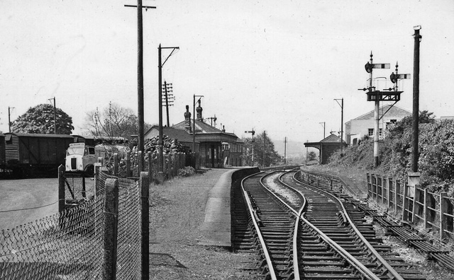
Brynmenyn Station.
View SW, towards Tondu and Pyle; ex-Great Western lines, Bridgend and Pyle via Tondu to Blaengarw by the Garw Branch (closed to passengers 9/2/53, still open 2010 - but disused [?] - as far as Pontycymer), and via the Blackmill Branch to Nantymoel (Ogmore Branch, closed to passengers 5/5/58, remainder open for coal from Ogmore Washery but in 2010 is mothballed). Also trains ran until 22/9/30 through Brynmenyn via Blackmill by the Gilfach Branch via Hendreforgan to Gilfach Goch and until 5/6/61 goods ran by the Hendreforgan Branch to Gellyrhaiad Junction on the Ely Valley Line (Taff Vale Rly.). |
| Date | |
| Source | From geograph.org.uk |
| Author | Ben Brooksbank |
|
Permission
( Reusing this file ) |
Creative Commons Attribution Share-alike license 2.0 |
| Camera location |
|
View this and other nearby images on: OpenStreetMap |
|
|---|
Licensing

|
This image was taken from the
Geograph project
collection. See
this photograph's page
on the Geograph website for the photographer's contact details. The copyright on this image is owned by
Ben Brooksbank
and is licensed for reuse under the
Creative Commons
Attribution-ShareAlike 2.0 license.
|
This file is licensed under the
Creative Commons
Attribution-Share Alike 2.0 Generic
license.
Attribution:
Ben Brooksbank
-
You are free:
- to share – to copy, distribute and transmit the work
- to remix – to adapt the work
-
Under the following conditions:
- attribution – You must give appropriate credit, provide a link to the license, and indicate if changes were made. You may do so in any reasonable manner, but not in any way that suggests the licensor endorses you or your use.
- share alike – If you remix, transform, or build upon the material, you must distribute your contributions under the same or compatible license as the original.