Bournemouth_UK_local_election_2007_map.svg

Size of this PNG preview of this SVG file:
800 × 508 pixels
.
Other resolutions:
320 × 203 pixels
|
640 × 406 pixels
|
1,024 × 650 pixels
|
1,280 × 812 pixels
|
2,560 × 1,624 pixels
|
1,425 × 904 pixels
.
Summary
| Description |
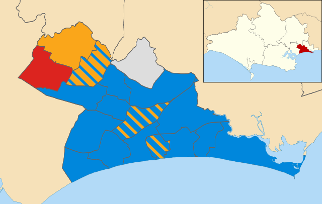
English:
Map of Bournemouth, Dorset, UK showing the results of the 2007 local election.
Colours:
Conservative
Independent
Labour
Liberal Democrats
Striped wards have mixed representation.
|
| Date | |
| Source |
This file was derived from:
Bournemouth UK ward map 2010 (blank).svg
:
|
| Author |
|
.svg)
Licensing
This file is licensed under the
Creative Commons
Attribution-Share Alike 4.0 International
license.
-
You are free:
- to share – to copy, distribute and transmit the work
- to remix – to adapt the work
-
Under the following conditions:
- attribution – You must give appropriate credit, provide a link to the license, and indicate if changes were made. You may do so in any reasonable manner, but not in any way that suggests the licensor endorses you or your use.
- share alike – If you remix, transform, or build upon the material, you must distribute your contributions under the same or compatible license as the original.