Boston-Mines-1945.jpg

Size of this preview:
800 × 567 pixels
.
Other resolutions:
320 × 227 pixels
|
640 × 453 pixels
|
892 × 632 pixels
.
Summary
| Description |
English:
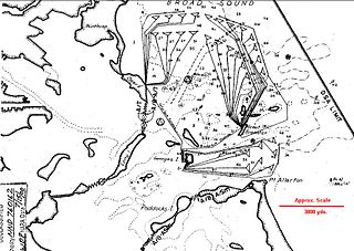
This map of the controlled mine fields protecting Boston Harbor in 1945 comes from the report "Supplement to the Harbor Defense Project: Harbor Defenses of Boston," U.S. Army Engineers, 31 January, 1945.
It shows 30 Groups of mines (the triangular symbols at the ends of the connecting cables), nominally of 19 mines per group, controlled (variously) from Ft. Dawes on Deer Island, Ft. Warren on Georges Island, and from Great Brewster Island. The map also indicates the boom and netting barriers that guarded the inner harbor by closing the channel between Long Island and Deer Island, the gap between Long Island and Moon Island, and the channels on either end of Peddocks Island. This image is an enlargement of a portion of the original map, which has been sharpened and had an approximate scale (in red) added for use on Wikipedia. |
| Source | see above |
| Author | US gov |
Licensing
|
|
This image or file is a work of a
U.S. Army Corps of Engineers
soldier or employee, taken or made as part of that person's official duties. As a
work
of the
U.S. federal government
, the image is in the
public domain
.
|
|
Original upload log
The original description page was
here
. All following user names refer to en.wikipedia.
| Date/Time | Dimensions | User | Comment |
|---|---|---|---|
| 2010-07-27 14:19 | 892×632× (140093 bytes) | Pgrig | This map of the controlled mine fields protecting Boston Harbor in 1945 comes from the report "Supplement to the Harbor Defense Project: Harbor Defenses of Boston," U.S. Army Engineers, 31 January, 1945. It shows 30 Groups of mines, nominally of 19 mines |