Blume_High_School,_southeastern_angle.jpg

Size of this preview:
800 × 600 pixels
.
Other resolutions:
320 × 240 pixels
|
640 × 480 pixels
|
1,024 × 768 pixels
|
1,280 × 960 pixels
|
2,560 × 1,920 pixels
|
2,816 × 2,112 pixels
.
|
|
This is an image of a place or building that is listed on the
National Register of Historic Places
in the
United States of America
. Its reference number is
96000933
.
|
| Camera location |
|
View this and other nearby images on: OpenStreetMap |
|
|---|
| Description |
English:
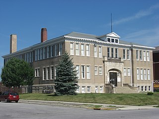
Front and southern side of the former
Blume High School
, located at 405/409 Blackhoof Street in
Wapakoneta
,
Ohio
,
United States
. Built in 1908 and since converted into apartments, it is listed on the
National Register of Historic Places
.
|
||
| Date | Taken on 26 July 2010 | ||
| Source | Own work | ||
| Author | Nyttend | ||
|
Permission
( Reusing this file ) |
|