Bhimfedimap.png

Size of this preview:
800 × 565 pixels
.
Other resolutions:
320 × 226 pixels
|
640 × 452 pixels
|
1,024 × 724 pixels
|
1,280 × 905 pixels
|
2,560 × 1,809 pixels
|
3,508 × 2,479 pixels
.
Summary
| Description |
English:
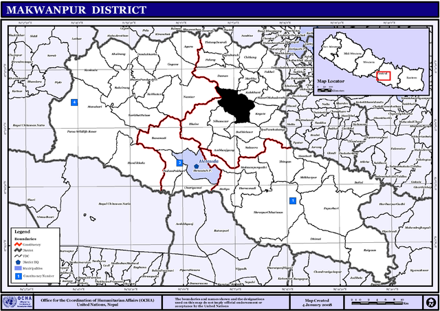
Map displaying Village Development Committees in Makwanpur District, Nepal
|
| Date | |
| Source | http://www.un.org.np/maps/district-maps/central/Makwanpur.pdf |
| Author | w:United Nations |
Licensing
|
|
This image is a map derived from a
United Nations
map.
Unless stated otherwise, UN maps are to be considered in the public domain. This applies worldwide.
UN maps are, in principle, open source material and you can use them in your work or for making your own map. UN requests however that you delete the UN name, logo and reference number upon any modification to the map. Content of your map will be your responsibility. You can state in your publication, if you wish, something like: based on UN map … (map name, map number, revision number and date). See: Geospatial Information Section . And: Geospatial, location data for a better world . |

|
Original upload log
The original description page was
here
. All following user names refer to en.wikipedia.
| Date/Time | Dimensions | User | Comment |
|---|---|---|---|
| 2008-12-09 14:26:29 | 3508× 2479× | Eukesh | |
| 2008-12-09 12:16:36 | 457× 451× | Eukesh | == Summary == {{Information |Description={{en|1=Map displaying Village Development Committees in Makwanpur District, Nepal}} |Source=http://www.un.org.np/maps/district-maps/central/Makwanpur.pdf |Date=January 4, 2008 |Author=[[United Nations]] |Permission |