Battle_of_Mount_Sorrel_-_Battle_Map_-_June_6_(restored1).jpg

Size of this preview:
373 × 600 pixels
.
Other resolutions:
149 × 240 pixels
|
298 × 480 pixels
|
477 × 768 pixels
|
637 × 1,024 pixels
|
1,741 × 2,800 pixels
.
| Description |
English:
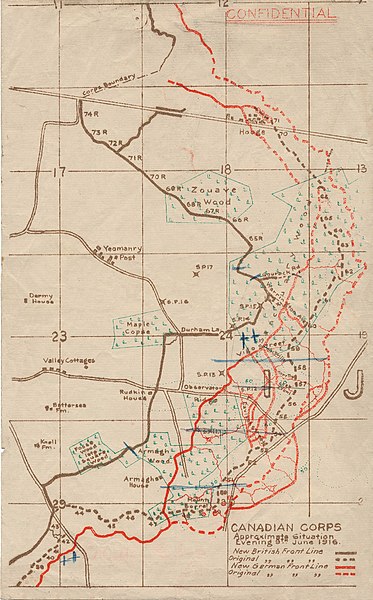
This map illustrates the British/Canadian positions (in brown) and the German lines (in red) on 4 June 1916, during the Battle of Mount Sorrel. The Canadians have been driven from several strong points, including Hooge north), Mount Sorrel itself (south), and most of Observatory Ridge (centre).
|
|||
| Date | ||||
| Source |
George Metcalf Archival Collection, Canadian War Museum: 19870027-018
[1] |
|||
| Author | n.d. | |||
|
Permission
( Reusing this file ) |
|
|||
| Other versions |

|

![[1]](http://www.warmuseum.ca/cwm/exhibitions/guerre/photos/2800/19870027-018.jpg)
|
|
This is a
retouched picture
, which means that it has been digitally altered from its original version. Modifications:
Tears, holes and major folds & creases repaired or decreased in intensity.
.
|
| Camera location |
|
View this and other nearby images on: OpenStreetMap |
|
|---|
.jpg¶ms=050.841342_N_0002.948456_E_globe:Earth_type:camera_scale:10000_region:BE_&language=en)