Bastille_in_Medieval_Paris_Map..png
No higher resolution available.
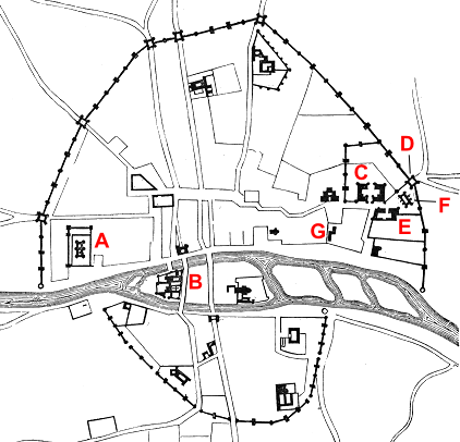
| Description | Map of Paris in 14th century |
| Date | (UTC) |
| Source | |
| Author |
|
|
|
This is a
retouched picture
, which means that it has been digitally altered from its original version. Modifications:
trimmed and labelled
. The original can be viewed here:
Plan.Paris.XIVe.siecle.2.png
:
|
|
|
This work is in the
public domain
in the
United States
because it was
published
(or registered with the
U.S. Copyright Office
) before January 1, 1929.
|
|
|
This work is in the public domain in its country of origin and other countries and areas where the copyright term is the author's life plus 100 years or fewer . This work is in the public domain in the United States because it was published (or registered with the U.S. Copyright Office ) before January 1, 1929. |
| This file has been identified as being free of known restrictions under copyright law, including all related and neighboring rights. | |
Original upload log
This image is a derivative work of the following images:
-
File:Plan.Paris.XIVe.siecle.2.png
licensed with Cc-pd-mark-footer, PD-1923, PD-old-100, Viollet-le-Duc
- 2005-08-30T17:26:39Z Buzz 558x712 (53855 Bytes) Plan de Paris au XIVe siècle. Élargissment des fortifications, pendant l'emprisonnement du roi Jean. Issu du Dictionnaire raisonné de l'architecture française du XIe au XVIe siècle, par Eugène Viollet-Le-Duc, 1856. {{ . A – the Louvre; B – Palais de Roi; C – Hôtel des Tournelles; D – Porte Saint-Antoine; E – Hôtel St Paul; F – the Bastille.
Uploaded with derivativeFX