Bananal-Island-North-End-Landsat-25-07-1992.png

Size of this preview:
600 × 600 pixels
.
Other resolutions:
240 × 240 pixels
|
480 × 480 pixels
|
768 × 768 pixels
|
1,024 × 1,024 pixels
.
Summary
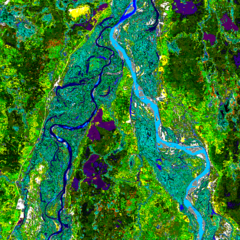
| Description | Landsat image of the northern end of Bananal Island, Brazil |
| Date | |
| Source | Landsat http://www.geog.ucsb.edu/~rivers/sa/bananal-web/cluster50.gif |
| Author | Landsat 5, US Government |
|
Permission
( Reusing this file ) |
Public Domain |
Licensing
|
|
This image is in the
public domain
because it contains materials that originally came from the U.S.
National Oceanic and Atmospheric Administration
, taken or made as part of an employee's official duties.
|
|
Original upload log
| Date/Time | Dimensions | User | Comment |
|---|---|---|---|
| 15 August 2006, 21:25:13 | 1024 × 1024 (508177 bytes) | Bejnar ( talk · contribs ) | {{Information |Description=Landsat image of the northern end of Bananal Island |Source=Landsat http://www.geog.ucsb.edu/~rivers/sa/bananal-web/cluster50.gif |Date= 25 July 1992 |Author= Landsat 5, US Government |Permission=Public Domain |other_versions= } |