Backa.png

Size of this preview:
560 × 599 pixels
.
Other resolutions:
224 × 240 pixels
|
449 × 480 pixels
|
918 × 982 pixels
.
Summary
| Description |
English:
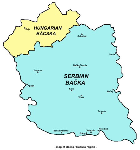
Map of
en:Bačka
region
Српски / srpski:
Мапа Бачке
|
| Date | 22 May 2006 (original upload date) |
| Source | Transferred from en.wikipedia to Commons. |
| Author | Original uploader and author was PANONIAN at en.wikipedia |
| Other versions |
|
.png)

Licensing
self made map by user:PANONIAN
|
|
This work has been released into the
public domain
by its author,
PANONIAN
at
English Wikipedia
. This applies worldwide.
In some countries this may not be legally possible; if so: PANONIAN grants anyone the right to use this work for any purpose , without any conditions, unless such conditions are required by law. |
References
References for historical/geographical borders of Bačka and modern state borders:
- Školski istorijski atlas, Zavod za izdavanje udžbenika Socijalističke Republike Srbije, Beograd, 1970.
- Milovan Radovanović, Kosovo i Metohija - antropogeografske, istorijskogeografske, demografske i geopolitičke osnove, Beograd, 2008.
- Slobodan Radovanović, Geografski atlas, Magic Map, Smederevska Palanka, 2001.
- Školski geografski atlas, Intersistem Kartografija, Beograd, 2004.
- Denis Šehić - Demir Šehić, Geografski atlas Srbije, Beograd, 2007.
References for sizable cities and towns:
- Popis stanovništva, domaćinstava i stanova u 2002., Stanovništvo, nacionalna ili etnička pripadnost - Podaci po naseljima, knjiga 1, Republika Srbija - Republički zavod za statistiku, Beograd, februar 2003.
- http://world-gazetteer.com/ archive copy at the Wayback Machine
Original upload log
The original description page was
here
. All following user names refer to en.wikipedia.
- 2006-05-22 13:18 PANONIAN 560×625×8 (26578 bytes)