Azuchimomoyama-japan.png

Size of this preview:
621 × 600 pixels
.
Other resolutions:
249 × 240 pixels
|
497 × 480 pixels
|
795 × 768 pixels
|
1,061 × 1,024 pixels
|
1,800 × 1,738 pixels
.
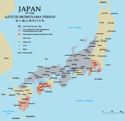
| Description | Map of Japan in the Azuchi-Momoyama period. | ||||||||||||
| Date | |||||||||||||
| Source | Self-made; base map from Demis MapClip ; all information from The Cassell Atlas of World History by John Haywood et al. (Cassell 1997) | ||||||||||||
| Author | Zakuragi | ||||||||||||
|
Permission
( Reusing this file ) |
I, the copyright holder of this work, hereby publish it under the following licenses:
This file is licensed under the
Creative Commons
Attribution-Share Alike
2.5 Generic
,
2.0 Generic
and
1.0 Generic
license.
You may select the license of your choice.
|


|
This
historical map
image could be re-created
using
vector graphics
as an
SVG
file
. This has several advantages; see
Commons:Media for cleanup
for more information. If an SVG form of this image is available, please upload it and afterwards replace this template with
{{

vector version available

|

new image name

}}
.
It is recommended to name the SVG file “Azuchimomoyama-japan.svg”—then the template Vector version available (or Vva ) does not need the new image name parameter. |