Antarctic_expedition_map_(Amundsen_-_Scott)-en.svg

Size of this PNG preview of this SVG file:
610 × 599 pixels
.
Other resolutions:
244 × 240 pixels
|
489 × 480 pixels
|
782 × 768 pixels
|
1,042 × 1,024 pixels
|
2,084 × 2,048 pixels
|
1,898 × 1,865 pixels
.
Summary
| Description |
English:
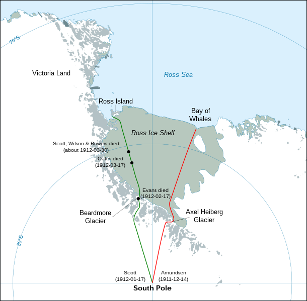
Map showing the polar journeys of the Scott's
Terra Nova
expedition (green) and Amundsen's expedition (red) to reach the South Pole
Français :
Carte montrant les parcours de l'expédition
Terra Nova
de Scott (vert) et celle d'Amundsen (rouge) pour atteindre le Pôle Sud
Español:
Mapa mostrando las travesías polares de la expedición
Terra Nova de Scott (verde) y la expedición de Amundsen (rojo) para alcanzar el Polo Sur.
|
| Date | |
| Source |
Own work using:
|
| Author | Shakki |
| Other versions |
[
]
|
-ar.svg)
-bg.svg)
-ca.svg)
-cs.svg)
-cs-colorswap.svg)
-de.svg)
-el.svg)
-en.svg)
-es.svg)
-fr.svg)
-ka.svg)
-no.svg)
-ru.svg)
-he.svg)
-zh-hans.svg)
-zh-hant.svg)
Licensing
|
|
I, the copyright holder of this work, release this work into the
public domain
. This applies worldwide.
In some countries this may not be legally possible; if so: I grant anyone the right to use this work for any purpose , without any conditions, unless such conditions are required by law. |
| Annotations | This image is annotated: View the annotations at Commons |
-en.svg)