A_Class_Roads_at_Stonehenge_-_geograph.org.uk_-_1626528.jpg

Size of this preview:
800 × 536 pixels
.
Other resolutions:
320 × 214 pixels
|
640 × 428 pixels
|
1,024 × 685 pixels
|
1,280 × 857 pixels
|
2,560 × 1,714 pixels
|
3,872 × 2,592 pixels
.
Summary
| Description |
English:
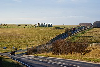
A Class Roads at Stonehenge If work goes to timetable, this view will be consigned to history by 2012. The A303, in the foreground, is planned to be modified. The A344, which passes close to Stonehenge, will be removed; leaving just a short access road from Airman's Corner.
|
| Date | |
| Source | From geograph.org.uk |
| Author | Peter Trimming |
|
Attribution
( required by the license ) |
Peter Trimming / A Class Roads at Stonehenge / |
| Camera location |
|
View this and other nearby images on: OpenStreetMap |
|
|---|
_heading:270.00&language=en)
| Object location |
|
View this and other nearby images on: OpenStreetMap |
|
|---|
_heading:270.00&language=en)
Licensing

|
This image was taken from the
Geograph project
collection. See
this photograph's page
on the Geograph website for the photographer's contact details. The copyright on this image is owned by
Peter Trimming
and is licensed for reuse under the
Creative Commons
Attribution-ShareAlike 2.0 license.
|
This file is licensed under the
Creative Commons
Attribution-Share Alike 2.0 Generic
license.
Attribution:
Peter Trimming
-
You are free:
- to share – to copy, distribute and transmit the work
- to remix – to adapt the work
-
Under the following conditions:
- attribution – You must give appropriate credit, provide a link to the license, and indicate if changes were made. You may do so in any reasonable manner, but not in any way that suggests the licensor endorses you or your use.
- share alike – If you remix, transform, or build upon the material, you must distribute your contributions under the same or compatible license as the original.