ASPA-126-Byers-Peninsula.png

Size of this preview:
800 × 562 pixels
.
Other resolutions:
320 × 225 pixels
|
640 × 450 pixels
|
1,024 × 719 pixels
|
1,280 × 899 pixels
|
1,848 × 1,298 pixels
.
Summary
| Description |
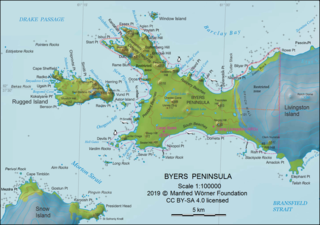
English:
L.L. Ivanov. Antarctia: Byers Peninsula. Scale 1:100000 topographic map. Manfred Wörner Foundation, 2019. Revised and updated version of the relevant fragment of the author’s 2010 map of Livingston Island and Greenwich, Robert, Snow and Smith Islands.
|
| Date | |
| Source | Own work |
| Author | Apcbg |
| Other versions | Fragment of the Commons file File:Livingston-Island-Map-2010.jpg |
| Camera location |
|
View this and other nearby images on: OpenStreetMap |
|
|---|
Licensing
I, the copyright holder of this work, hereby publish it under the following license:
This file is licensed under the
Creative Commons
Attribution-Share Alike 4.0 International
license.
-
You are free:
- to share – to copy, distribute and transmit the work
- to remix – to adapt the work
-
Under the following conditions:
- attribution – You must give appropriate credit, provide a link to the license, and indicate if changes were made. You may do so in any reasonable manner, but not in any way that suggests the licensor endorses you or your use.
- share alike – If you remix, transform, or build upon the material, you must distribute your contributions under the same or compatible license as the original.
Published by the Manfred Wörner Foundation, and hereby released by the Foundation’s President and CEO Apcbg (Lyubomir Ivanov) for publication under the Creative Commons Attribution ShareAlike 4.0 license.