2013_Woolwich_attack_map.PNG
No higher resolution available.
Summary
| Description |

The tower block on the right is Elliston House.
English:
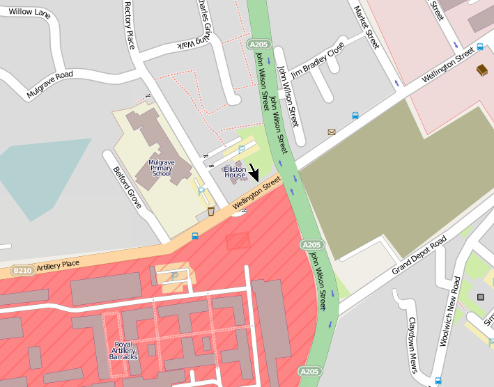
Location of
2013 Woolwich attack
, created using OpenStreetMap data
The location of the incident is marked with an arrow in the centre. Elliston House is a
tower block
. The incident took place in Wellington Street near the junction with John Wilson Street. The site of the attack is on the perimeter of the
Royal Artillery Barracks
.
The image on the right shows Elliston House, and the road sign into which the car crashed during the attack. Map co-ordinates: 51°29′19″N 0°03′45″E / 51.4885°N 0.06255°E Google Street View is here . |
| Date | |
| Source | Own work |
| Author | Ianmacm |
Licensing
|
|
This work contains information from
OpenStreetMap
, which is made available under the
Open Database License (ODbL)
.
The ODbL does not require any particular license for maps produced from ODbL data. Prior to 1 August 2020, map tiles produced by the OpenStreetMap Foundation were licensed under the CC-BY-SA-2.0 license . Maps produced by other people may be subject to other licences. |
This file is licensed under the
Creative Commons
Attribution-Share Alike 3.0 Unported
license.
-
You are free:
- to share – to copy, distribute and transmit the work
- to remix – to adapt the work
-
Under the following conditions:
- attribution – You must give appropriate credit, provide a link to the license, and indicate if changes were made. You may do so in any reasonable manner, but not in any way that suggests the licensor endorses you or your use.
- share alike – If you remix, transform, or build upon the material, you must distribute your contributions under the same or compatible license as the original.