2010_Maule_earthquake_intensity_USGS.jpg

Size of this preview:
510 × 599 pixels
.
Other resolutions:
204 × 240 pixels
|
612 × 719 pixels
.
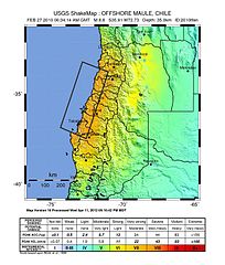
Summary
| Description |
English:
Shake map of the
magnitude 8.8 earthquake
offshore
Chile
on February 27, 2010. Epicenter marked at star. Seventh version of the map, realized by
USGS
on 5 March 2010 at 03:00:13 AM MST.
|
| Date | |
| Source | USGS |
| Author | USGS |
| Camera location |
|
View this and other nearby images on: OpenStreetMap |
|
|---|
Licensing
|
|
This image is in the
public domain
in the United States because it only contains materials that originally came from the
United States Geological Survey
, an agency of the
United States Department of the Interior
. For more information, see
the official USGS copyright policy
.
|
|