1908_Cape_Colony_parliamentary_election_map.svg

Size of this PNG preview of this SVG file:
800 × 467 pixels
.
Other resolutions:
320 × 187 pixels
|
640 × 373 pixels
|
1,024 × 597 pixels
|
1,280 × 747 pixels
|
2,560 × 1,493 pixels
|
1,003 × 585 pixels
.
Summary
| Description |
English:
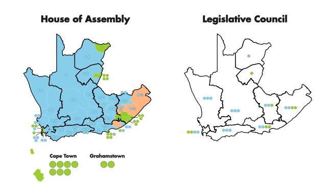
Map of the results of the 1908 Cape Colony parliamentary election, showing the party of the winning candidate by constituency.
Left map shows results by constituency for the House of Assembly election. Right shows results by province for the Legislative Council election. Constituencies marked orange returned 2 different candidates from different parties. Blue - Ind/Afrikaner Bond alliance candidates victorious Green - Progressive Party candidates victorious Grey - Independent candidates victorious |
| Date | |
| Source | Own work |
| Author | MrPenguin21 |
Licensing
I, the copyright holder of this work, hereby publish it under the following license:
This file is licensed under the
Creative Commons
Attribution-Share Alike 4.0 International
license.
-
You are free:
- to share – to copy, distribute and transmit the work
- to remix – to adapt the work
-
Under the following conditions:
- attribution – You must give appropriate credit, provide a link to the license, and indicate if changes were made. You may do so in any reasonable manner, but not in any way that suggests the licensor endorses you or your use.
- share alike – If you remix, transform, or build upon the material, you must distribute your contributions under the same or compatible license as the original.