1845_trailmap.png

Size of this preview:
800 × 475 pixels
.
Other resolutions:
320 × 190 pixels
|
640 × 380 pixels
|
993 × 589 pixels
.
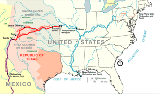
| Description | Santa Fe Trail around 1845 plus connecting trading routes to commercial hubs and ports in the USA | |||
| Source | http://www.nps.gov/beol/trailmap.gif | |||
| Author | NPS-graphics | |||
|
Permission
( Reusing this file ) |
|
Original upload log
| Date/Time | Dimensions | User | Comment |
|---|---|---|---|
| 26 July 2006, 11:15:24 | 993 × 589 (44064 bytes) | H-stt ( talk · contribs ) | {{Information |Description= Santa Fe Trail around 1845 plus connecting trading routes to ports in the USA |Source= http://www.nps.gov/beol/trailmap.gif |Date= |Author= NPS-graphics |Permission= {{PD-USGov-NPS}} |other_versions= }} [[Category:Santa Fe Nat |